USGS LAKE PHILIPPA
TWIN PEAKS
(USGS Lake Philippa (one L, two Ps), also USGS Devils Slide & Mount Phelps)
Home Court Peak
St. Patrick's Day, March 17, 1996
Party: John Roper, Jeff Howbert , Mike Torok
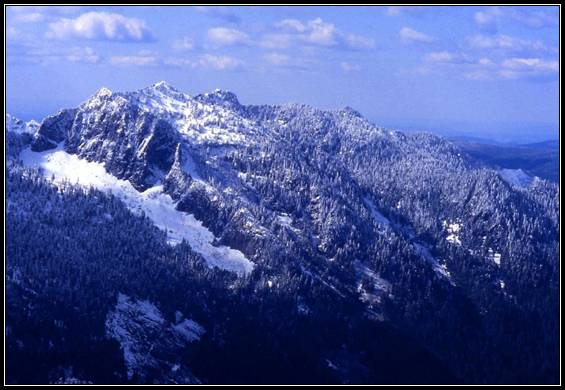
Twin Peaks from The Ark/Mowitch Mtn JR, March 24, 1996
--This summit gained some notoriety a few years ago when a weird TV series bearing the Twin Peaks name was shot in part in Snoqualmie and North Bend. After we went looking for the "Log Lady," even Mike, "the Torch" (crowned for his frequent after-dark, flashlight returns) admitted this was a "real hard trip"--4700' vertical brush and 12 miles on our last winter climb in 1996.
The route annoyed us from the beginning, lying on the corners of three 7.5' USGS quads (hey, it was before Topo!). Jeff was to blame for the "short cut" to this "Home Court" peak of his via Loch Katrine, though I admit it did pass the muster as a good plan on paper.
We drove up the NFk Snoqualmie River Road from North Bend, crossing the river on the "Wagner Bridge," about 10 miles after the pavement ends. In another 2 miles, the gated Philippa Creek road is on the right. We parked here and walked the road east across Philippa Creek to the nose of the ridge that headed south to Twin Peaks . The USGS map made it look like we only had 300 vertical feet to gain from the base of the nose to a "4WD" spur that would whisk us up to the main Loch Katrine Road.
This is a map myth/lie. In reality, that nose from 1600 to 2640 feet, took us 2 hours, and is about as bad as it gets. Weyerhaeuser has selectively thinned this ridge, falling about 3/4ths of the third-(?) growth trees here, leaving them on the ground to let the light in to the rest. It was a 1000-foot struggle, worse than any natural blowdown ever is, and lots of unkind words were spoken, grunted, yelled. We dubbed Jeff's route the spoonerism, "Koch Latrine Ridge."
Finally arriving at the 2640+ foot switchback on the main (but gated) Loch Katrine road, I for one was wiped and ready to call it a day and retreat down the road to Sunday Creek (the preferred ascent route), and loop back to the car. But the easy, perfectly maintained mile-long road segment straight into Loch Katrine (2900') was so seductive and fast, we all suppressed the bail-out idea and the ordeal we'd just endured.
However, pain was soon the watchword again as we thrashed our way around the west side of Loch Katrine. Instead of the hoped-for fisherman's trail, we suffered a half-mile of Devil's Club and other sticker bushes, whose needles are still erupting from little pustules on my knees and hands a week after the trip as I write this.
My guess is that Loch Katrine was named after the Scottish lake made famous in Sir Walter Scott's poem, Lady of the Lake . The other famous "Lady of the Lake," who gave the sword Excaliber to King Arthur, is a totally different romantic story. But I bet this Loch Katrine name and the Morgan Le Fay and Merlin Lake names (from Arthurian legend) on USGS Snoqualmie Lake all had the same author.
We walked soft snow up the inlet stream of Loch Katrine, and after crossing the first south tributary creek, headed due south up a ridge toward Upper Loch Katrine. This proved to be another brushy mess until we finally reached more firm, continuous snow at 3400'. Finally able to zoom, we did to a 5040+' NW subsummit of Twin Peaks, where we continued a ridge run on south to the lower (NW) Twin Peak, 5245 feet.
Persevering to the true 5325-foot SE summit, nearly 7 hours from the car, we found the familiar helicopter-landed wire and plastic trash of past littering USGS surveyors, and a broken down cairn with no register.
This could have been a great viewpoint, the map said, but for the clouds, straight down into the quad namesake, Lake Philippa, and south and SE to Bessemer, Quartz, and Garfield, as well as to three unofficially-named peaks in the Home Court 100 rimming Sunday Creek: "Boomerang Peak" (5185), "Paperboy Peak" (5013), and "Mowitch Mtn"/TheArk (5339). We felt lucky to see briefly the bulky Goat Mountain, and not-so-hot Dog, and Upper Loch Katrine, our exit route.
Glissading into Upper Loch Katrine, we turned immediately right, east, and followed down a gully, first on the right to 3300', then on the left, finally working down to the barely-recognizable Sunday Creek "trail" at 1900'.
Another 4 miles north on the trail took us by Sunday Lake, through the old growth that Harvey Manning drooled over in Footsore and Sound to Mtns to the Sunday Creek ford, and out the Sec 13 Road over an impressive "down-to-bedrock" washout (triggered by a clearcut above) and the "Sunday Swamp" (thanks to a sinking road), finally to the N Fk Snoqualmie Road, which we trudged in the dusk-dark back to the car by Braille. 6 hrs 50min up, 5 hrs down.
We had no time for a "cup o' Joe" and a piece of pie at the "Twin Peaks Cafe," even though we were curious to hear if Laura Palmer had ever been found, ending Agent Dale Cooper's agonizing search.