
|
1964 Peak
7160+
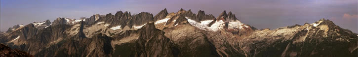
Glee Peak Glee is also the far right peak in Gregg Brickner's panorama above. This day started an hour before midnight. Tex and Monte Steere, my cousins, and I piled into my Aunt Dawn's '57 Chevy and drove the Seattle to Newhalem run in about 3 hours, arriving at my folks' house at 2 AM. My parents were out so we had to do without Mom's famous blueberry pancakes. Three hours is not enough sleep, but we were up and off by 5 AM, driving up the Goodell Creek road. Tex had 30 feet of plastic boat rope wrapped around his waist for use in case we ran into any "technical climbing." In those days, the drivable road ended 200 feet before "Straight Shot Creek." (In this aerial photo link, Newhalem is at the bottom, the Southern Pickets at the top. Look at how straight this creek is as the fault it runs in extends over the ridge into Jay Creek.) Today, the road is washed out 20 minutes by trail farther downstream. My dad and I had scouted the overgrown Goodell logging road and its several dead-end spurs a couple of years before. We may have even gone fishing up here, but I never remember Goodell Creek being particularly good for that. But by 1964 I knew the secret of the Goodell Trail: Always take the right (uphill) fork. The left forks take you to the stream or into the brush. So we made the right turns and reached the creek at the end of the overgrown "road" in good time. Here in the stream were two logs jackstrawed into a perfect "X" and situated where to get across the creek you'd stand on this slippery, half submerged "X" or use it as a handhold as you walked beneath it. We turned uphill just past this "Over-and-Up Creek" and were somewhat surprised to find a pretty decent tread after a brief bit of brush. The trail wasted no time going up, though we occasionally lost it in the salal. At 3200 feet the tread petered out but the woods were nicely open to make for a pleasant ascent to the talus and rock terraces above timberline. Triumph loomed majestically behind us. We reached the crest between Goodell and Stetattle Creek by 1 PM . We had no compass, but figured that our shadows should be pointing north at 12 noon (Standard Time). Our goal was to climb "High Ross," the name my dad applied to the 7200-foot peak, about 4 miles north of the map-named Mt. Ross, at the end of the ridge that heads north out of Newhalem. He felt we should climb this peak as logical follow-up to our ascent the previous year of Trapper's Peak and Big Devil Peak. These peaks are all Newhalem neighbors. After some discussion here, we decided that the gentle ridge heading up to the south of us led to Peak 6705 and our charge was to make the peak to our north. We were not pleased with the idea of having to lose 300 feet of hard-won elevation to get to the low point between it and us, and Monte gave the universal digital dissatisfaction symbol as I shot a picture of him doing a free-standing glissade into the notch. This was likely the place that Glee Davis and Burton Babcock stood in 1905. We scrambled around a humpy sub-summit and were standing on the top of "High Ross" at 3 PM . The Pickets were touchable. Azure Lake lay directly below us and surprisingly was still partially frozen at the end of September.
Glee Peak and Azure Lake from NE, near Elephant Butte Taken October 14, 1978 There was a small cairn on the summit that we dismantled to find an odd rusty tin of mating halves. The faint words "Oxo Bullion Cubes" were barely recognizable. We opened this with historical anticipation, and carefully pulled out a wet piece of blue and yellow cardboard, the remains of a Grape Nuts box. On it were written the names and comments of the first ascenders of this peak, unfortunately they were undecipherable. Years later, I wrote to the Post Grape Nuts people telling them what a great mountain food Grape Nuts was and asked when they quit boxing their product in blue and yellow packages. In 1946 or 47, they answered. Within a few months they started making those macho ads about how "Grape Nuts is right for you, but are you right for Grape Nuts?" I now think the first climb may have been done by the 1938 group of Ptarmigans. Ours was likely a second. The hour was late, the sky was whitening, a cool SW wind was blowing trouble our way, and we weren't prepared to spend the night, so we quickly signed ourselves in, took a few pictures and made for home. We arrived back at the car just before dark and were back in Seattle by 11 PM, 24 hours after leaving home where a tired Monte echoed his father's words after he'd climbed Mount Stuart in the '40s: "I'm not going to climb another peak unless there's a lake on top or I can ski down." Copyright 2004, John W. Roper, MD. All Rights Reserved. |

