CORNICE PEAK'
7800+ feet. Prominence 440 feet.
In CAG3 as Blue Lake Peak and Wamihaspi Peak
USGS Washington Pass
May 15, 2004
John Roper
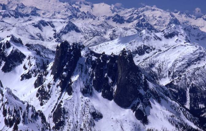
This 7800+ summit is a climbing anticlimax to the granite-on-steroids monsters of the Liberty Bell-Early Winters Spires group at Washington Pass. It sits just to their south, and though it is not nearly as imposing, there is a chance it is the highest of the cluster, since South Early Winters Spires (SEWS) is measured just a smidge above at 7807 feet. It drains water into State (through Blue Lake) and Copper Creeks to Bridge Creek to Stehekin River and Lake Chelan, and Early Winters Creek to the Methow.
The peak could use a new name. Peaks are not lakes. Beckey had a source that called it Wamihaspi Peak, without explanation, but what the heck is that? This is not a Chinook or English word. This mountain is one of the only summits I can think of that is listed twice by different names in the index of a Cascade Alpine Guide.
The name Cornice Peak would be well-suited, applied for the distinctive snowy eave that hangs over the high NE shoulder just under the summit, often long into the summer. You can call it what you want, of course.
[The week after our climb, I shopped the Wamihaspi question around to those who might know its origin, and got a clever response back from Dallas Kloke, John I have no idea how it came by that name. Indians must have made the first ascent. Cute. I knew that if anyone would know, it would be Harry Majors, and indeed he did, pointing to R. Duke Watson's climbing record found and reported by Lowell Skoog at alpineglow.com.
Watson and his friends, Milner, Hall, and (Warren) Spickard climbed this peak in August 1960, and applied the Wamihaspi tag after the first few letters of their last names. Watson was with Dr. Spickard when he fell to his death off NW Mox the following year. Lowell dug further into Duke's notes and came up with names for other party members, Jons Milner and the Hall family (Dave, Nonie, Ros, and possibly Don), so that solves that puzzle.]
Cornice on Cornice Peak on 4.29.04 Photo by wildstar at SummitPost
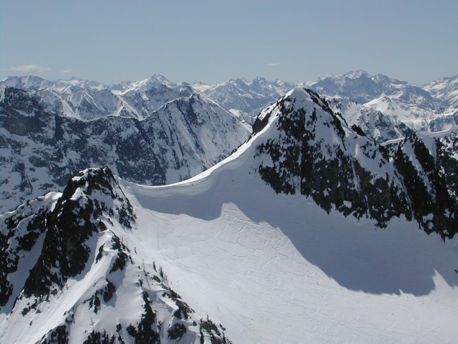
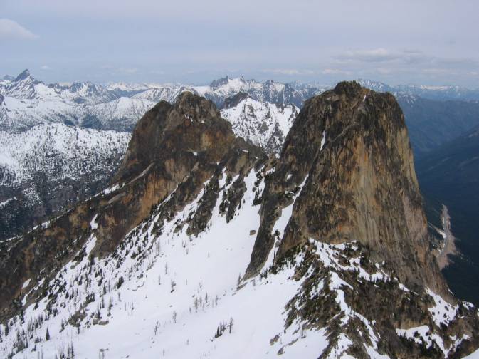
View from South Early Winters Spire (my 1975 shot from here was washed out by cloud cover). Note the many ski tracks. The cornice route goes up through the break on the left.

NW Basin of Cornice Peak Wow photo by leejams on Summitpost
Fred Beckey credits himself with a probable first ascent on September 28, 1946 (in a very rare instance where Fred uses the probable term on himself), in the company of Jerry O'Neil and Chuck Welsh the day after they made the FA of Liberty Bell. I climbed Rainier with Chuck in 1967 along with my sister and his stepdaughter. Fred does not mention this summit in the 1949 or 1961 editions of Climber's Guide to the Cascade and Olympic Mountains of Washington. Not that it needs much of one, but he also does not offer a route description in the 1981 or 1995 Red Fred.
Map of area. Crosshair is on 7800+ Cornice Peak.
Ian, Jerry, and I altered our plan to climb Sunny Girl above the N, M, and S Fk of the Cascade at the forecast of deteriorating weather. After a 60 mph glance from the car at another possible peak before Rainy Pass, we decided on this very pleasant conditioner, parking at the Blue Lake trailhead, just shy of Washington Pass, ~5400 feet, near MP 161, opposite Cutthroat Peak. The TH is not marked on USGS , and seems drawn too far SW on the 1996 Green Trails .
There was still a couple feet of snow at the park on a very dry year. The dozen-car lot was full, since this is also the approach to Liberty Bell and the Early Winters Spires, and popular spring ski slopes. Don't expect solitude. Despite the full lot, there was not a tracked groove in the snow to the high country because of some firmness.
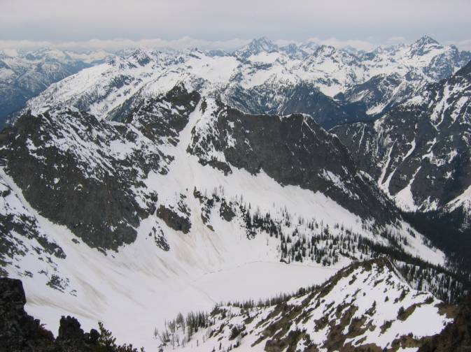
A couple of ways to do this peak are obvious from the west side. One is to climb through the open woods (on trail later) to Blue Lake, and the other is to make your way to the saddle between SEWS and Cornice Peak on snow or a climbers path. We did the latter up, entering the lovely open basin shown in the photos above, and came down the valley into Blue Lake.
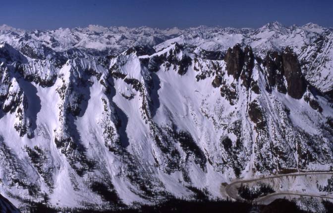
The photo below from the Cutthroat (west) side shows the entire approach up the snow gut to various climbs and skis on this flank, with Cornice Peak on the right, Early Winters Spires left-center, and Liberty Bell left. The Blue Lake route is off the photo to the right.
West approach from Cutthroat slopes John Roper 4.29.89
The 7360- foot SEWS-Cornice Peak gap defines the 440-foot prominence of this peak. The gap drops easterly to the hairpin on HW 20 on the Early Winters Creek side via a slope termed Spiral Gulch. It looks like an unlikely ski on the map, but the photo below shows the connection. Fred Spicker, who inspired and maintains the Blue Lake Peak page on Summitpost.org and obviously loves this area, has signed into the summit register here a ton (9 times in spring between 1990 and 2004), and has some shots there of the ski down Spiral Gulch.
View from east (Big Kangaroo). HW 20 Hairpin lower right. Spiral Gulch to Cornice Peak is above Hairpin. Liberty Bell and EWS directly above road. Washington Pass at right edge. Four other bowls off the hairpin beckon spring skiers. John Roper 4.30.89
Skiers call various renditions of the route from Blue Lake TH over the ridge to the Hairpin, The Birthday Tour.
Our route to Cornice Peak went up the west basin to the bowl between SEWS and Cornice Peak to the gap between them, then up a steepish snow slope to the 7600' corniced shoulder through a break on the left (almost always there), just NE of the 7800+ top. From here the final 200-foot pyramid can be climbed directly on snow (early in a full snow year), but because of a rocky band, we angled left to a midpoint on the pyramid up a solid steep 10-foot step with a pine for supplemental handholds.
Except for the crowds of climbers yelling belay instructions, skiers whooping it up on the slopes below with their barking dogs, tracks all over the place, and the highway noise, I can't think of a more rewarding, easy early season destination in this area. 2.5 hours up.
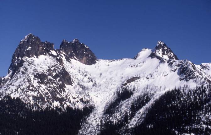
Cornice Peak left, EWS-Liberty Bell group center, Washington Pass lower right. Viewed from Silver Star.
John Roper 5.25.75
Liberty Bell left, SEWS right, HW 20 in Early Winters Creek from Cornice Peak summit. JR 5.15.04
Frozen Blue Lake from Cornice Peak. JR 5.15.04
After photos around, unfortunately muted by an approaching storm, we headed south down the ridge above Copper Creek to the first saddle that dropped right into Blue Lake. Here a short gully leading into the broad basin above the lake was negotiated, first plunge stepping, then facing in as the snow got stiff, finishing with seat glissades after the steepish section.
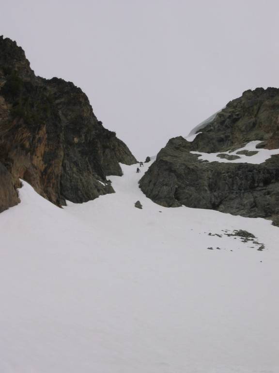
Jerry and Ian in gully above Blue Lake
We returned around the north bank of Blue Lake, rejecting the challenge to shortcut over its frozen, white surface for fear of the thin, telltale pale-blue rim.
____________________________________________________________
THE NEEDLES
~8170'
Prominence ~1730!
May 27, 1991
USGS Washington Pass
Party: JR, Silas Wild, Martin Shetter, Rob Freeman
The Needles are a wonderful rock montage. There is only one name here on the map, but even counting coarsely, there are at least 5 summits in this cluster. Most climbers come in and do the highest Needle and leave, satisfied that the job is done. That's understandable, and about how we did it, but there is more exercise and entertainment to be had here if you want it.
The Needles are in the Top 100 by the 1000-foot Prominence Rule. Stephen Fry initially worked the numbers for this list and will soon publish it in the Mountaineer Annual (old news now in 2012).
This is one of the only summits where Helmy Beckey is credited with a first ascent without his brother Fred. And he did it the hard way, as they had to do the Washington Pass peaks in the old days, walking up the trail from near Mazama to Pine Creek. Helmy and Larry Strathdee came in here in September 1944, when I was 8 months old, and the rest of our party weren't even gleems in their mothers' eyes.
The old 1961 guide calls this a class 4 climb. The 1981 guide is more accurate, saying there is 20 feet of 5.5, a lieback in an open book (of sorts).
Silas Wild , Rob Freeman, and Martin Shetter were scheduled to meet me the night before the climb at Lone Fir Campground on the North Cross State Highway, right beneath The Needles. Martin, Silas, and I had been sporadically fussing with the Top 100 list by the 1000-foot Rule. Rob would rather be skiing.
And the three boys had a great ski the day before, picking off Graybeard, another summit with over 1000 feet of prominence above ridge level, with a nice run back down from Easy Pass. They didn't turn up at Lone Fir on the appointed night, probably because the campground was closed. The Forest Service did not want to get sued. Trees were falling down here and there periodically from some mysterious root disease. This perturbs light-sleeping campers. The FS figures it'll take all season to figure out which trees to cut down to make the place safe. Kicking the biggest tree I could see, and deciding it'd last the night at least, I pitched my tent under it.
The next morning the boys turned up at 7:15 AM, which we'd agreed to do if we failed to rendezvous the previous night. We'd actually agreed on 7 AM but I forgot to factor in "Silas Time." We left the cars in a little turnoff between Pine Creek and Lone Fir CG, elevation 3600.
The first 2000 feet are advertised as brushy by everyone we've talked to who's done it. Our route, though, was pretty much whistle-clean. The trick is to avoid Pine Creek, taking to the woods between the first and second small streams immediately downhill from Pine Creek. The other trick is to do this climb early in the year. We were here on Memorial Day.
The youngsters gave the rope to the old fat guy (me), then smoked up the hillside, burning up the first 2100 feet in an hour and 15 minutes before breaking for a drink. After some minor whining the loads were equalized. We hit snow at 4600 feet, and it supported us well early in the day as we followed the fall line to timberline then did a gradually ascending traverse under the east Needles.
To the south, across Pine and Cutthroat Creeks, we were most impressed by the little-known Fickle Fingers (aka State Crags, now Hinkhouse) 7560+ (just north of Washington Pass) and its lower 6978 satellite summit with a steep, complex 1000-foot north ridge.
We avoided a corniced ridgelet dropping toward Pine Creek off the 7920+ foot third Needle, crossing it high, about 7750. From here we could see the noteworthy 200-foot dark peg of rock that Helmy felt was the summit. The map shows this summit though as 8040+. The 8140-foot highest point shown on the map appeared to be only a minor bit of rock beyond a snow plume to our right.
There was some discussion as to whether to do the "Harder '8040+' Needle" or the "Higher 8140 Needle" first. With his eye on the black ugliness coming at us from the "wrong direction" (the east), first smothering the Gardners, then Silver Star, Rob was quick to vote for the rock climb. We tended to go along with him on this trip since his footprints were usually a couple hundred feet ahead of ours.
The route is obvious. You are naturally led to the base of the east wall of the peg. The rock here is that marvelous Golden Horn granite with big, sticky grains. While Rob and Martin roped up a more difficult pitch to the right, Silas and I third-classed 80 feet up a shallow depression straight ahead from where the rock climb starts. We passed a rusted piton with a new rap sling just before the comfortable ledge at the base of the class 5 pitchlet. We all started this pitch lying back a bit, using the lip of a crack on the left for the hands, then stemmed over to footholds on the right. 20 feet of modest awkwardness in plastic boots and the climb was over. Martin stuck with the lieback the whole way and looked good. This requires long legs. A rare piece of hail fell as Rob took me off belay. Time to the top was 5 hours. 7:30 AM start, 12:30 PM on top.
The water-tight summit register was placed in 1968. This peak was climbed about every four years initially, then about once every year or two in the last decade. Familiar names were Mike Bialos, John Spezia, Jim Price, John Burroughs, Joe Vance, Dallas Kloke, Mark Dale, and the incredible Pete Doorish, who with 3 others, on July 22, 1989, cleaned out all the horrendous looking west Needles, putting up three 5.10 routes with up to 8 pitches (see sketch copied from his summit note). The Needle immediately west of the summit spire is a skinny classic.
We all agreed that the summit the Washington Pass quad calls 8040+ is actually higher than the 8140-footer. We did two 80-foot raps from a point less than 40 feet below the summit, which would make the rock pyramid about 200 feet high, but the USGS shows only 80 feet of contours here. So if the missing 120 feet were added to the USGS's height of 8040+, a more accurate estimation of 8160+ is likely. The adjustment to 8170 raises The Needles rank from 76th to 71st on Fry's 1000-foot Rule List.
After a brief lunch we scrambled (over one move) to the top of the 8140 summit just to double check this height problem. No doubt about it, this summit is lower. From here we sited over to the harder (and higher) Needle which hid the 8200-foot Mount Arriva behind it.
Since the May snow was softening up, we decided to return on a straight shot down to Pine Creek via the creek basin draining directly south off 8140. We had a fabulous sitting glissade down "Kicking-ass Couloir," losing 3500 feet in 35 minutes to Pine Creek! (We kicked tail getting down this, and it kicked ours right back on a very bumpy ride.)
We were back to the cars in a surprising 1 hour and 10 minutes from the summit, after Silas led us like a wildman-on-a-mission through the moderately brushy mile down Pine valley.
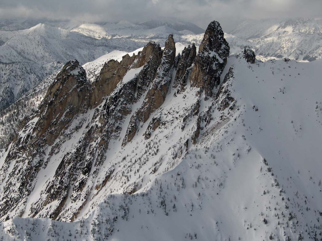
Great John Scurlock shot of The Needles