STORM KING MOUNTAIN
4750 Feet
Prominence 2230 Feet
USGS Mineral and Glenoma
Party: John Roper, Jeff Howbert, Reed Tindall
September 12, 1999
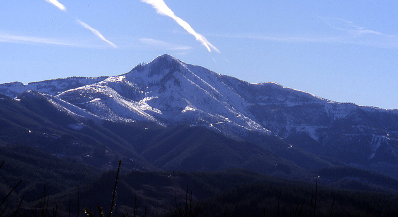
Storm King Mountain 4750 Feet
From north, on Stumptop Mountain
This is a Pack and Pedal report. It was good to be on the road again with old biker friends, Jeff and Reed. This particular Storm King (there are at least three in WA), at a modest 4750', lies halfway between Elbe and Morton, just east of HW 7. It's biggest claim to fame is that it has over 2200' of prominence, as its SE ridge dips to 2520 feet, then rises to the next higher summit, Kiona Peak.
The trip was fraught with problems for our threesome. At the start, Reed discovered he'd left his bike seat at home, bad news. He strapped some padding on the open hole with a piece of manila rope. Then I realized I'd left my lunch on the kitchen counter. Luckily, I found a left-over Power Bar in the trunk. Unluckily, it was a Power Bar, if you know what I mean.
We found our way safely around a gate at 1100' near Ladd Pond off HW 7 that seemed OK, after encountering an inhospitable, Murray Pacific Logging gate/sign that did not talk the Native Washington tongue, claiming to exclude motorized vehicles (no problem, we agree), but speaking also of no public access. Come on guys! These are Washington mountains! Keeping out the motors is always OK, but let the feet of Washingtonians walk or pedal where they may, at least on weekends!
We pumped up the road paralleling the E Fk of Tilton Creek, dodging bullets of some maniac target/game-shooter lower down, then took a left turn at the pass 6.5 miles from HW 7. This summit-bound road had been freshly graded, which made it pretty much impossible to ride. Reed became disgusted enough with the pushing endeavor to head back down after another 3 miles. He left a note on my car on his return that he'd suffered a flat tire on the exit, and rode the last 7(!) miles out on the rim, as if no seat wasn't bad enough. Ouch.
Jeff and I persevered to the top of Storm King (12 miles from HW 7) and enjoyed a panorama that a 2270 foot-prominence peak gives. Rainier , as always, dominated the scene, and made it's immediate surrounding 2000-foot prominence peaks (Wow, High Rock, Purcell, Unicorn, Curtis Gilbert) look like pimples. A flying red ant convention on the very top made us have lunch a few feet below the top, near a small shack and antenna.
We decided to satisfy loop requirements and avoid the graded road by returning via a road that headed down the north, then the south side of the ridge that separated Tilton River (HW 7) from Nineteen Creek. All went well for about 1000 feet down, then as soon as Jeff cheered our good choice, the road became decommissioned and reverted to berms and tight 20-foot-high alders. Bad enough, but pushable, then after a couple of miles, we ran into rock slides across the road, the first couple a minor, dangerous nuisance, but then a serious slide wiped out more than 100 yards of the mountainside to bedrock, which would have been difficult enough to cross without a bike, but we had em.
We debated a full retreat, but decided to endure, lugging our bikes over the monster slide. Once we reached the other side, we were totally wiped out. Jeff had lost his odometer, ripped off by brush in this crossing, and my rear brake was caught along the way by a mean bush and twisted beyond function. Jeff was kind enough to fix it while I collapsed and drank the last of my water.
The road eventually improved, but on the final ride down, I was exhausted enough to take a header when my front wheel hit a rogue rock. I catapulted forward, splattering and bruising my tired body on the rocky road. Luckily, all parts seemed to gather themselves and hold together, and we continued the ride back to the car. My left thigh and outer butt now look like an eggplant over an area about the size of a medium-large one. 3.75 hours up, 2.5 hours down.
Back to Mountain Stories.